

This month marked the ninth anniversary of the tragic and mysterious disappearance of MH370 — a Boeing 777 flying between Kuala Lumpur, Malaysia, and Beijing on March 8, 2014. To this day, there is no solid explanation of what happened to the aircraft.
The event is shrouded in confusion and controversy. How a piece of multimillion-dollar machinery and all its passengers and crew can disappear into thin air is the most perplexing element of the story.
It’s a common belief that every aircraft appears as a little blip on the air traffic controller’s screen. You’ve probably seen a movie where that blip dramatically disappears, spelling disaster for the aircraft involved.
However, it may come as a surprise that aircraft aren’t always visible to air traffic control as that little blip. In some parts of the world, air traffic control doesn’t have the equipment to detect the aircraft and, thus, has no screen on which to display them.
That said, no matter what facilities are available for air traffic control, there are always several layers of safety procedures to ensure that aircraft are safely separated from each other. In fact, the aftermath of the disappearance of MH370 resulted in the global body for civil aviation making changes to how aircraft are tracked.
Flight MH370
In the early hours of March 8, 2014, flight MH370, a Boeing 777-200, took off from Kuala Lumpur International Airport (KUL) for a scheduled flight to Beijing. After climbing to 35,000 feet and approaching the edge of Malaysian airspace, the crew was instructed to contact Vietnamese air traffic control at 1:19 a.m., Malaysian time.
To do this, air traffic control passes the pilots a new radio frequency that they repeat back to confirm that they have understood it correctly. This is what they did. It would then be standard procedure for the pilots to change the radio from the Malaysian frequency to the new Vietnamese frequency and contact Vietnamese air traffic control. However, that radio call was never made on the new frequency.
Three minutes later, at 1:22 a.m., the flight disappeared from air traffic control’s screens, and no one heard from it again.
Radar control
The most common way air traffic control keeps track of aircraft is by radar. The origin of this system dates back to World War II when British scientists developed technology to detect German aircraft inbound to the mainland of the United Kingdom.
Primary surveillance radar
The simple form of radar developed by the Brits is now known as primary surveillance radar. It uses a beam of electromagnetic wave energy sent out into the sky by an emitting station.
As this wave travels out toward space, anything it might bump into (like an aircraft) acts as a deflector. This causes some waves to bounce back to the ground, where a receiving station picks up the signal. This radar return is then displayed on a screen for the radar operator, who can determine the aircraft’s distance and relative bearing.
Using multiple stations, it eventually became possible to overlay the signals and work out the approximate altitude of the aircraft.
However, this system has its limitations in both range and accuracy. The radar signal will create a return if it hits anything — including thunderstorms, hills and even small objects like birds. As a result, it could often be difficult for the radar operator to be sure of exactly what the return was indicating.
This was fine in the early days of commercial aviation. Still, as the skies became busier and airspace more congested, air traffic controllers needed a better, more accurate way of tracking aircraft that would ensure flight safety.
Secondary surveillance radar
To address the growing challenges of using the original radar system in busier airspace, a new system called secondary surveillance radar was developed. Instead of sending out a signal from the ground and relying on it hitting aircraft, this system uses an interrogator station and a piece of equipment on the aircraft called a transponder.
Before departure, pilots receive a specific four-digit number to enter into their transponder, identifying that aircraft to air traffic control. This is known as the squawk code. The interrogator station can then send signals to the specific aircraft, requesting certain pieces of information. When the transponder receives these requests, it sends back a coded signal containing the demanded information.
The transponder can operate in two modes. Mode C returns the aircraft’s position, squawk code and altitude to 100 feet. In addition to the position and squawk code, Mode S sends the altitude accurately to 25 feet, as well as the aircraft’s call sign (for example, “United 26LP”), the magnetic heading, the indicated airspeed, the groundspeed and the rate of turn. It also shows the controller what altitude the pilots have instructed the plane to climb or descend to.
All this extra information lets air traffic control know exactly what the aircraft is doing without wasting time asking the pilots. It’s particularly useful to controllers sequencing aircraft on the final approach to a runway because it allows them to ensure that one aircraft isn’t catching up with the one ahead. Additionally, since the controller can see what altitude the pilots have set for the autopilot, air traffic control can pick up any errors before they become major threats.
One major weak point of secondary surveillance radar, though, is that it still requires a ground-based radar system to detect the aircraft’s position. This is fine over land where radar stations are plentiful, but as soon as the aircraft flies over large areas of rainforest, desert or water, the aircraft can no longer be tracked.
A good example of this is over the Atlantic Ocean. On either side of the pond, as part of Canadian and Irish/Scottish air traffic control, good radar coverage allows for accurate position determination by radar. However, as aircraft fly farther away from land, radar can no longer detect them. Instead, a very simple method known as procedural control is used.
Procedural control
Before the invention of a more sophisticated system like secondary surveillance radar, the pilot could pass a position report to very simply determine aircraft positions. The report would contain a message with the plane’s position, altitude and speed. Air traffic control would keep a note of this and be able to build a picture of an aircraft’s current location, as well as where an aircraft would be in the next minutes and hours.
When flying over the Atlantic, a similar system called procedural control is used.
The busiest part of the North Atlantic is divided into a series of motorways called tracks; each track has entry and exit points.
Before starting the crossing, pilots tell air traffic control their requested altitude and speed at which to cross and the time they will reach the entry point. Air traffic control collates this information from all the flights that wish to cross and assigns each aircraft an altitude and speed depending on when they reach the entry point. Pilots must then fly exactly as instructed by air traffic control.
Doing this results in each aircraft flying at least 1,000 feet away from others. If there are multiple planes at the same altitude, they will fly at the same speed, ensuring that one aircraft doesn’t catch up with another. So, once an aircraft leaves the radar coverage zone, air traffic control knows it will remain safely separated until it’s picked up by radar on the other side.
ADS-B
The procedural control system works well, but it needs large safety buffers built into it since it can’t track aircraft in real time. Because of this, fewer aircraft can cross the Atlantic in a set time, which sometimes results in delays.
A system that would enable air traffic control to know the exact position of an aircraft, even when outside radar coverage, was necessary. So, the automatic dependent surveillance-broadcast system was created.
ADS-B works much like the secondary surveillance radar system but the other way around. Instead of a ground station interrogating the transponder, the transponder itself sends out a signal that stations on the ground or other aircraft can pick up.
The name may sound somewhat complicated, but it describes exactly how the system works. ADS-B is automatic because it does not require interrogation by another system; it automatically sends out its own data. It is dependent because this information depends on data (such as the aircraft position) provided by the aircraft systems to send out surveillance information to other stations. Finally, this data is broadcast, and the sender has no idea who picks up the signal.
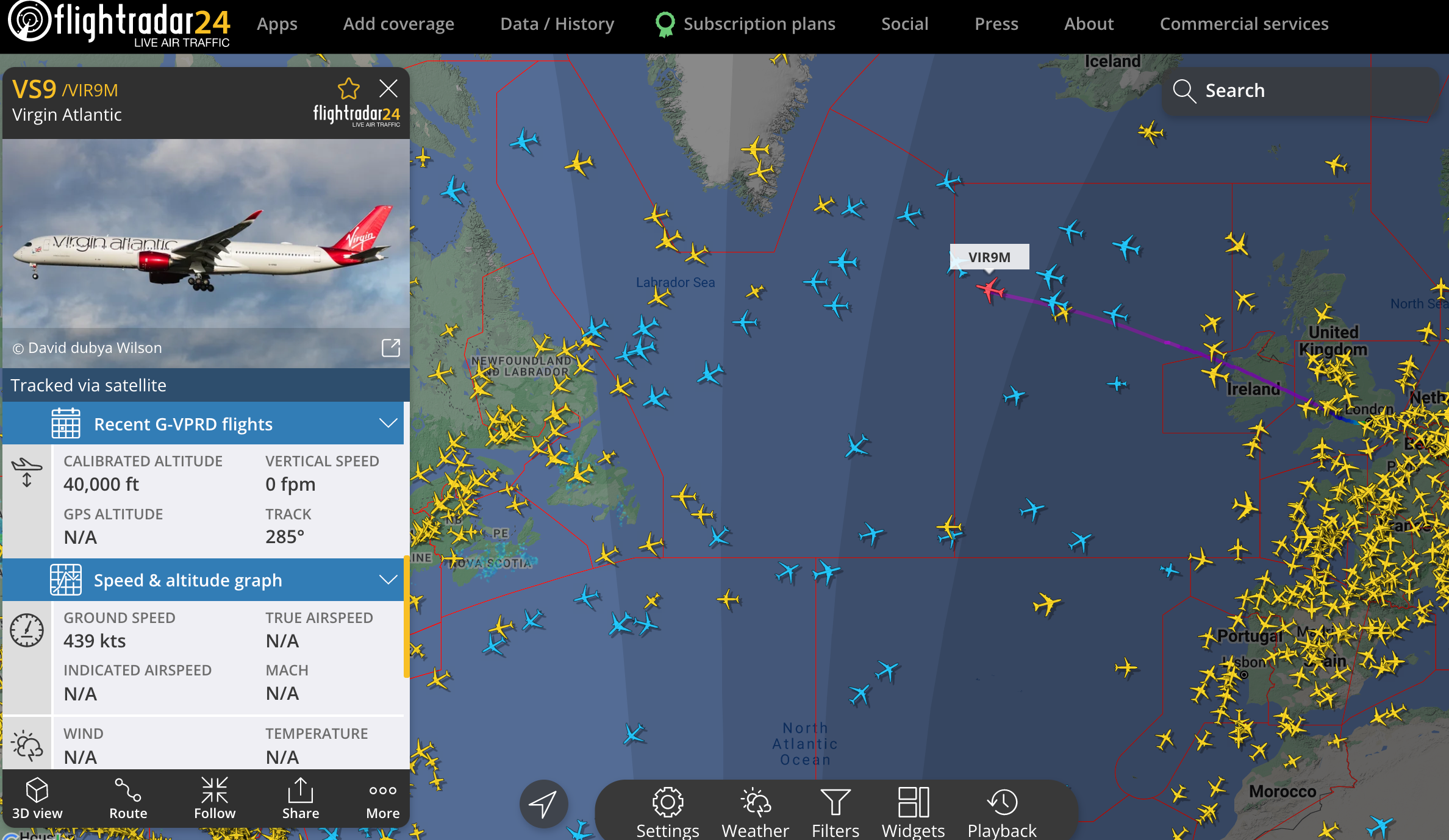
The major benefit of ADS-B information is that instead of requiring the reach of a ground-based radar station, the signal can be transmitted up into space. Satellites then redirect it back to air traffic control, enabling air traffic control to see in almost real time where exactly an aircraft is and what it is doing. A great example of this is flight tracking programs such as Flightradar24.
Flightradar24
Sites like Flightradar24 use various data sources to allow the user to see the position of an aircraft almost anywhere in the world, plus data such as its altitude, speed and heading. This is because these sites can access ADS-B receivers to get accurate data.
Most of this data comes from ground-based ADS-B receivers, but when aircraft are out of their range — for example, when over the Atlantic — they can also access data transmitted by satellites. This means the information is so accurate that you can watch an aircraft pass over you on your phone at the same moment it physically passes over your head.
Bottom line
Modern-day technology on commercial airliners is so good that air traffic control can track the aircraft’s position even when it’s flying over an ocean. Improvements in ADS-B accuracy have allowed air traffic control to reduce the minimum lateral separation of aircraft over the Atlantic from 60 miles down to 30 miles and increase the frequency of communication between aircraft and ground stations. As a result, almost double the number of transatlantic flight routes can occur at any given time without extended periods of silence, allowing more aircraft to safely fly their most optimum and fuel-efficient flight profile.
While we may never find out the reason behind MH370’s disappearance, the tragedy brought about much-needed advancements in tracking technology to ensure most aircraft can stay connected to those on the ground, no matter where they’re flying.